Evacuation and Logistics Planning Project
Project Overview
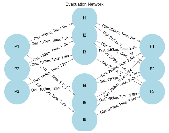
This project develops a comprehensive evacuation model using a directed graph to optimize the routing and resource allocation for individuals and families needing to evacuate from a crisis-stricken country. The model addresses one of the most critical challenges in emergency management: efficiently moving large populations to safety while minimizing travel time and maximizing operational effectiveness.
By leveraging advanced operations research techniques and optimization algorithms, this simulation provides actionable insights for strategic planning and decision-making during critical emergency evacuations.
Network Architecture
Primary Locations
Initial evacuation points where individuals and families begin their journey
Intermediate Stops
Transit hubs that facilitate distribution and resource management
Final Destinations
Safe zones where evacuees reach their ultimate destination
Network Design Principles
- ✓ Primary locations feed into multiple intermediate stops to distribute load
- ✓ Each node in the network is actively utilized to prevent bottlenecks
- ✓ Intermediate stops connect to final destinations with capacity constraints
- ✓ Network structure ensures redundancy and alternative routing options
Optimization Objectives
Minimize Travel Time
Optimize routing to reduce total evacuation time while considering road conditions, traffic patterns, and transportation capacity.
Maximize Safety
Prioritize routes that avoid high-risk areas while ensuring adequate security and medical support at each node.
Balance Resource Allocation
Distribute evacuees efficiently across available transportation and shelter resources to prevent overcrowding at any single location.
Maintain Network Flow
Ensure continuous movement through the network while adhering to capacity constraints at each node and edge.
Model Features
Directed Graph Modeling
Network flow optimization using graph theory principles
Capacity Constraints
Real-world limitations on transportation and shelter resources
Multi-Stage Routing
Three-tier network structure for flexible evacuation planning
Bottleneck Identification
Automatic detection of potential choke points in the network
Real-World Applications
Emergency Response Planning
Government agencies and humanitarian organizations can use this model to prepare for natural disasters, conflicts, or other crisis situations requiring mass evacuations.
Military Operations
Optimize troop and civilian movements during non-combatant evacuation operations (NEO) or humanitarian assistance missions.
Disaster Relief Logistics
Coordinate the distribution of aid supplies and personnel through multi-stage logistics networks in disaster-affected regions.
Technical Implementation
Technologies Used
View Full Implementation
Explore the complete optimization model with code, visualizations, and detailed analysis.